Articles from the Thoroton Society Newsletter
Gibbet Hill, Shelford
By Ivan Morrell
Gibbet Hill is named after a mound which stands on the edge of the Malkin Hill ridgeline, lying just within Shelford’s parish boundary with extensive sight lines across and along the Trent Valley. Excavations here in the early 1970s (1) discovered sherds of Romano-British pottery in the natural soil level below the mound suggesting it was post-Roman in date. The mound was apparently created by throwing soil up from the surrounding land as no evidence of a ditch was found which appears to rule out the mound being the remains of a motte or round barrow. The proximity of Spellow Hill near to the Radcliffe/Saxondale/Shelford parish boundaries probably also rules out the mound as a moot-site. The excavation came to the conclusion the feature was probably a gallows mound from the beginning of the medieval barony of Shelford held by the Norman Geoffrey Alselin, although there is no actual evidence that hangings took place there.
No thought appears to have been made that the mound could have been constructed as a preConquest look out point. There is evidence from the civil defence systems of Wessex that our Anglo-Saxons ancestors created mounds to aid the look-outs overlooking specific important locations. There is every possibility then that after the re-conquest of the Five Boroughs by Eadward the Elder in 920 and again later by King Edmund in 942 that similar structures were constructed when they began to install the civil defence system down the Trent Valley.
Shelford along with Stoke (Bardolph) on the opposite bank of the river in 1066, were held by Toki, son of Auti the Moneyer, the shire’s second senior ranking thegn listed behind Ulf Fenman in Nottinghamshire Domesday. The ford between Shelford and Stoke (Bardolph) appears to have been one of the fords in the area utilized by the late Anglo-Saxon route known as the Herryway.
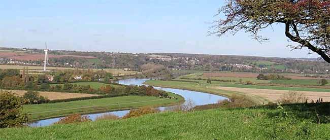 Plate 1. View looking north from Gibbet Hill, Shelford, looking down on the Shelford to Stoke Bardolph Trent crossing. The actual fording site lies adjacent to the houses in Stoke just visible below the wind turbine and a little upstream of the Ferry. The burh or enclosure at Burton Lodge Farm, from which Burton Joyce was named, and possibly the next watch-site downstream, lies conveniently above the next river bend on the ridgeline, centre picture. The manor at Burton Joyce although recorded in the Domesday Book as being held by the thegn Swein, was listed along with Toki's Shelford and Stoke estates that were inherited after the Conquest by the Norman Geoffrey Alselin. The probable reason for this was that Toki in fact held Burton Joyce and Swein was his tenant.
 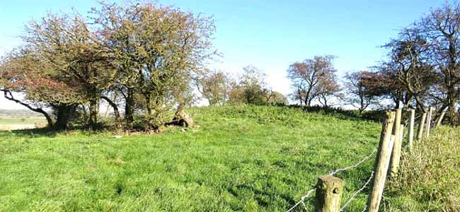 Plate 2, View of the mound at Gibbet Hill
 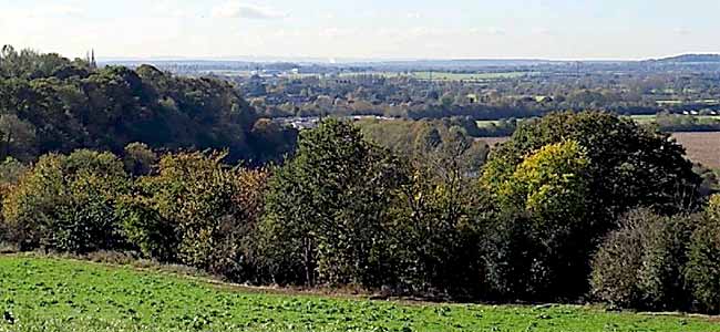 Plate 3, Panorama view looking southwest from Gibbet Hill, Shelford. The plume of smoke/steam left of centre marks the site of the gypsum factory on the East Leake ridgeline at Hotchley Hill; to its left lies the Costock ridgeline, to its right Court Hill at Gotham. The Beacon Hill range at Charnwood can just be made out through the haze far distance behind the gypsum factory. Sharp Hill at Edwalton lies on the skyline on the right of the picture.
 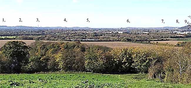 Plate 4, Continuation of the panorama from Plate 3 looking south-west from Gibbet Hill, Shelford.
1, Sharp Hill, Edwalton. 2, Wilford Hill, along with Sharp Hill were held by the Countess Gytha in 1066. This ridgeline is a favoured location for Eadward the Elder's 2nd burh lying directly opposite to Nottingham, ideally located to control the routes to the West Bridgford and Wilford fords. 3, Radcliffe on Soar Power Station. 4, The Clifton Estate flats 5, The Clifton Woods ridgeline, site of the pre-Conquest comital manor of Clifton, although held by the Countess Gytha, the Earl still held his jurisdiction over Clifton and its estate in 1066. 6, Toton Hill promontory. 7, Trent Building, University of Nottingham, possible site of Morcere's Newbold manor along with its Lenton sokelands in Broxtowe Wapentake. 8, Queen's Medical Centre, Lenton. 9, Colwick Hill; the western part of the hill was part of Sneinton parish falling under the jurisdiction of Nottingham. A watch site, Warde Forlonge, was located at the top of Colwick Hill.
Ideally located, a look-out point on this site satisfies two main criteria. First, it overlooks the Trent crossing between Shelford and Stoke (Bardolph) having sight lines to both of these settlements to which it was attached, in addition to Stoke’s sokelands at Carlton, Colwick and Gedling.
This capability ensured control of the access routes to the ford. Somewhere on the opposite Gedling ridgeline, lay the 14th century names of the Bernepit upon Wulfhowe and The Brende (2). Whether these names had any signalling connection with Gibbet Hill in control of the routes to the ford or have been coined perhaps from some industrial use is not known. Other similar ridgetop names are known from the same north bank of the Trent in the area around Nottingham, Brentwood from Sneinton and the Burnt Hills at Bramcote.
The second criteria is that Gibbet Hill connects into the greater lookout and beacon system down the Trent Valley. Connection to Newark and Southwell was possible via Mickleborough Hill (3) in Averham Parish, connection with Nottingham hidden behind Colwick Hill possibly went the Sharp Hill / Wilford Hill ridgeline, or via the watch site on top of Colwick Hill (4). Addition sight lines from Gibbet Hill to the comital manor of Clifton; the site of the Domesday manors of Warborough in the vicinity of Hoe Hill on the Clipston ridgeline; the Costock ridgeline where the then London to York road first comes within view of both the borough of Nottingham and the comital manor of Clifton Ramsdale Hill in the royal manor of Arnold; the Flintham beacon site and the Beacon Hill ridgeline at Charnwood.
Notes:
1. An Excavation at Gibbet Hill, Shelford. - Stanley Revill - Transactions of the Thoroton Society of Nottinghamshire Vol LXXV, p59-67, 1971.
2. The Brende - 1330, Bernes Pit - 1335/36, Bernepit upon Wulfhowe - 1346. - Records of the Borough of Nottingham.
3. It may or may not be a co-incidence that the only two instances of the name Mickleborough Hill in the county in Averham and Ruddington parishes are a) on sight lines with the only two Domesday boroughs in the shire, namely Nottingham and Newark; b) both had important preConquest routes running over or around their flanks, the then London to York road over Mickleborough in Ruddington and the Mansfield to Newark route over Mickleborough in Averham, giving them the capability of control over these routes. The names in both cases are said to have derived from O.E. Micel and Beorg, big hill.
4. Warde Forlonge Sneinton, 1518, - Nottinghamshire Archives Ref No M24/297.
< Previous