Articles from the Thoroton Society Newsletter
Tornado over Nottingham in 1785
By John Wilson
A tornado caused considerable damage in the Nottingham area in 1785. Fortunately, we have a very full account of the incident1.
The 31st of October had been overcast with some thunder in the evening. The morning of 1st November was clear with a south-westerly wind, but about 11 in the morning the sky became overcast and there was heavy rain at intervals until the afternoon, when the wind dropped. At about 4pm, there was the first sighting of what Laird describes as a ‘waterspout’. He is technically incorrect here, as a waterspout only forms over an expanse of water. What was seen, from the descriptions, was undoubtedly a funnel-cloud. A funnel-cloud consists of a rapidly rotating patch of cloud which then descends in the shape of a funnel. If the funnel-cloud reaches the ground, it is usually then referred to as a tornado. A water-spout is a funnel-cloud that touches down over water.
The funnel-cloud ‘proceeded from a dense cloud, apparently about a quarter of a mile to the southward of the Trent, and moving slowly towards it’. It was observed that trees were bent right over as the funnel-cloud passed over them. ‘As the cloud came nearer to the river, it appeared to be strongly attracted by it, and when it crossed did not seem more than 30 or 40 feet from the surface of the water, which was violently agitated and few upwards to a great height in every direction’.
Some people, standing on Trent Bridge, mistook it at first for a column of thick smoke, possibly from a fire in a warehouse by the river. At this point, the funnel-cloud was about 300 yards from the bridge. However ‘..they were soon undeceived, and now beheld with astonishment a large black inverted cone, terminating nearly in a point, and in which they perceived very plainly, a whirling spiral motion whilst a rumbling noise like thunder was heard at a distance.’ After passing the river, the column rose ‘slowly and majestically in a NE direction; and nothing coming within the limits of its electric power, until it came over Snenton[sic]’. At Sneinton, there was considerable damage. The thatch was torn from several barns and cottages, and apple trees were torn up by the roots. One tree was said to be nearly four feet in circumference but it was broken off near the ground. A barn ‘nearly 30 yards long’ was demolished and the adjacent house was severely damaged. ‘In short, nothing could resist the impetuosity of its action; and the rain falling heavily at the time, joined to the roaring noise of the spout, produced among the spectators a scene of terror and confusion which, they acknowledged, was not easy to be described.’
A tavern on the edge of the village had part of the roof torn off by the storm. The people within ‘were almost all of them seized with a painful sensation in the head, which lasted some hours’. [This may have been caused by a violent change in air pressure, such as one gets if an aeroplane descends too quickly]. A local market place was thrown into confusion, with people hurled with great violence against the hedge. A 14 year old boy was carried over the hedge into the adjacent feld, fortunately without injury. There was much lightning seen around the tornado and as it passed over the hill opposite the tavern, ‘it was observed to contract and expand alternately, as if it had been attracted, and repelled, by some extraneous force. The phenomenon continued for some twenty minutes’.
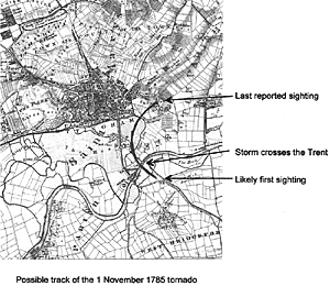
I have attempted a simple analysis of the track of the tornado, for such it proved to be. It is diffcult to be sure of the location of the storm at its first sighting. A witness said ‘quarter mile south of the Trent’. Using Sanderson’s map of 18352 I have located the first sighting somewhere near the north of the then village of West Bridgford. The tornado then crossed the river about 300 yards from Trent Bridge. I suggest that this point is downstream of the bridge, which is where warehouses may have been situated at that time. The storm then swung to the northeast and over the small village of Sneinton where most of the damage seems to have occurred. It was last reported passing over the hill behind the tavern (probably the hill on which Green’s Mill now stands). The measured track on the map is some 1.3 miles. Of course, the tornado may have travelled much farther, but there are no further eye-witnesses, as the land beyond Sneinton may have had few inhabitants. It may also not have been seen from the land near West Bridgford, before the first sighting, again because of the low population of the area. With the phenomenon being visible for some 20 minutes, this puts the movement of the tornado and its associated clouds at around 4mph, a brisk walking pace, which would be consistent with the account of the wind dropping (it is rare for there to be a dead calm). Although tornados are not unknown in the English Midlands, this is most unusual weather for November!
I am unaware of any similar incident in the Nottingham area causing so much structural damage, although fortunately no-one was seriously hurt and there were no fatalities.
I thank Nottinghamshire County Council for permitting the use of the map, and Bromley House Library for permission to quote from Mr Laird’s book.
1. Francis Charles Laird A topographical and historical description of the county of Nottingham c.1813. Local History Collection, Bromley House Library. Accession number Cc1290
2. Sanderson’s map ‘Twenty Miles round Mansfeld’ 1835. Facsimile edition Notts County Council 2005
< Previous