Articles from the Thoroton Society Newsletter
JOHN SPEED 1610
By Ken Brand
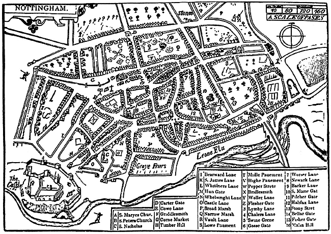
John Speed's map of Nottingham.
In 2007 John Beckett and I were disappointed, but not surprised, that Nottingham City Council showed little interest in celebrating the bicentenary of the birth of Thomas Hawkesley the greatest water engineer of the nineteenth century. With that in mind I doubt if the city will acknowledge the 400th anniversary of John Speed's Plan of Nottingham of 1610. This plan of Nottingham is an insert in the top left-hand corner of perhaps the most widely known early map of Nottinghamshire.
John Speed was born at Farndon in Cheshire in 1552. As he had no cartographic training he relied largely on the maps drawn by Saxton and Norden for his "Theatre of the Empire of Great Britain" published in 1611. The town plans came from a variety of sources. The whole project was beautifully engraved by the Dutchman, Jodocus Hondind the Elder. Many maps were sold separately, uncoloured, mostly as with Nottinghamshire dated 1610. Numerous editions of Speed's map were published with small alterations and additions down to 1770.
The plan of Nottingham gives a good if somewhat generalised layout of Nottingham early in the 17th century. There are a number of inaccuracies, for example the location of Carter Gate and Wheelwright Lane and the pictorial representation of housing is over generous on certain streets, for example, Broad Street and Greyfriar Gate. (This is judged against an accurate survey of 1739 noted in Deering.
Nevertheless, the plan has a rare sketch of the town's ruined castle and the surviving stretch of town wall and ditch extending to Chapel Bar. The 'wall' dividing the Market Square (G) is marked as are other features: the stocks and pillory, the Butter and Hen crosses but no Malt Cross. The earlier St. Nicholas' Church (C) is depicted complete with spire. Weekday Cross is drawn in approximately the correct position as is the gateway 'bar' at the top of Vault Lane (Drury Hill). Overall, the plan provides a chance to evaluate the extent of the survival of the medieval street pattern.
It is interesting to note the dominance of the route northwards from the Leen Bridge, via Hollowstone (not named), Stoney Street and beyond avoiding the centre of the town. Housing has spread to the foot of the sandstone cliff, in Narrow Marsh and Broad Marsh, but development has not yet reached the Leen. The population was About 3,500 living in an area of some 2,000 acres.
Next year sees the 150th anniversary of the publication of those twin snapshots of Victorian Nottingham, 'maps' of 1861 by Salmon and by Jackson.