Thoroton Society Record Series
Thoroton Society Record Series Volume XL (1997). Sherwood Forest in 1609: a Crown survey by Richard Bankes. Edited by Steph Mastoris and Sue Groves
The edition of the Survey of Sherwood Forest in 1609 is the culmination of fifteen years' work by the two editors, Steph Mastoris and Sue Groves. The original written royal survey (in the Public Record Office, London) lists nearly 2,000 individual plots of land in 46 Nottinghamshire parishes ranging from Nottingham in the south to Mansfield and Clumber in the north. For each plot the name of the owner, occupier and often the field is given, along with its acreage and some indication of whether it was open arable fields, enclosures, common pastures or woodland.
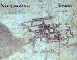 The
written survey is complemented by maps relating to nearly half of these
places mainly in the Nottingham -- Bestwood -- Calverton -- Lowdham area
showing virtually every house and plot of land. "The maps are astonishingly
accurate for their date", says Steph Mastoris, "Most can be directly
compared with modern Ordnance Survey maps. However, the original 1609 map
was in such a poor state it was sometimes impossible to distinguish a field
boundary from a crease! It has had to be meticulously redrawn and published
as 20 separate parish sheets".
The
written survey is complemented by maps relating to nearly half of these
places mainly in the Nottingham -- Bestwood -- Calverton -- Lowdham area
showing virtually every house and plot of land. "The maps are astonishingly
accurate for their date", says Steph Mastoris, "Most can be directly
compared with modern Ordnance Survey maps. However, the original 1609 map
was in such a poor state it was sometimes impossible to distinguish a field
boundary from a crease! It has had to be meticulously redrawn and published
as 20 separate parish sheets".
The survey volume and the maps are enclosed in an attractive slipcase printed with a full-colour reproduction of the original map showing Nottingham town, which has significant differences from the well-known near-contemporary plan by John Speed.
The text is fully indexed and contains some 5,000 personal names and nearly 1,000 field names.